Please see the information below regarding the predicted summer season outlook.
“VCC Emergencies Ministry is gearing up for the summer season ahead.”
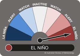
Australia is officially in an El Niño event after a La Niña pattern brought three years of cool temperatures and record-breaking rain.
The Bureau of Meteorology (BoM) has made the long-awaited announcement ending months of speculation.
What is El Niño and how is it different to La Niña?
The cycle of La Niña and El Niño – known as ENSO, or the El Niño-Southern Oscillation Index – works a bit like a pendulum.
La Niña occurs when water in the eastern tropical region of the Pacific Ocean is cooler than average as the “trade winds” – the planet’s prevailing east-to-west winds – strengthen, creating warmer-than-normal water around Indonesia and Australia’s east coast.
This leads to increased rainfall and brings the risk of heavy flooding in Australia.
However, when those conditions are reversed – trade winds are weaker, and water is warmer than average in the eastern tropical Pacific but cooler close to Australia – an El Niño is declared, and our continent will experience hot, dry conditions and come under the threat of drought.
When the “pendulum” sits in the middle and ocean temperatures are closer to average, it is referred to as “neutral” ENSO conditions – and it is more likely to bring less extreme weather conditions.
And, if you’re wondering what the two terms mean, “La Niña” is Spanish for “the girl” or “little girl”, while “El Niño” translates to “the boy” or “little boy”.
What is El Niño predicted to bring?
Put simply, the weather event will bring hotter, drier conditions, which will, in turn, increase the likelihood of bushfires.
It is Australia’s first El Niño event in about eight years.
The declaration came two months after the United Nations’ World Meteorological Organisation had previously declared El Niño’s arrival, predicting hot weather and tumbling temperature records.
Conditions for an El Niño event have met the required three of four criteria, the BoM said today.
“Oceanic indicators firmly exhibit an El Niño state,” it said in its climate driver update today.
“Central and eastern Pacific sea surface temperatures continue to exceed El Niño thresholds.
“Models indicate further warming of the central to eastern Pacific is likely.
“Overall, there are signs that the atmosphere is responding to the pattern of sea surface temperatures in the tropical Pacific and coupling of the ocean and atmosphere has started to occur.
“This coupling is a characteristic of an El Niño event and is what strengthens and sustains an event for an extended period.”
When was the last time Australia had an El Niño?
Australia’s last El Niño event occurred during the summer of 2015-16, while the last time the Bureau declared an El Niño alert was in April 2019.
The country had a severe drought throughout 2019 and the strong El Niño system was partly responsible.
The 2019 drought was measured by the BoM to be Australia’s most intense ever recorded.

In preparation for the Summer season, VCC EM is actively recruiting new volunteers Statewide and will be hosting core training and refresher training sessions for our EOC (Emergency Operations Centre) volunteers, along with recruiting additional volunteer Operations Officers to bolster our capability and capacity for the months ahead.
If you are interested in becoming a volunteer with VCC Emergencies Ministry, please visit vccem.org.au to find out more, or call any of the staff on (03) 7037 6010 for additional information.
Information provided by Edmund Murphy, Chief Operations Officer, VCC Emergencies Ministry